
From parameter tuning to mission execution, UniGCS v3.0 integrates gimbal control, data link management, flight controller configuration, and propulsion system calibration into a single software platform. Built for multi-rotor UAV pilots who demand professional-grade control without complexity.
What’s New in UniGCS v3.0?
Following four months of user feedback since the v2.0 release, SIYI has delivered a comprehensive upgrade that transforms how pilots interact with their entire unmanned system.
One-Stop Parameter Tuning
Integrated adjustment for gimbals, remote controllers, flight controllers, and propulsion systems. No more switching between Mission Planner and QGroundControl—everything lives in one interface.
Telemetry Log Playback
Automatic local recording of telemetry data with dynamic flight trajectory replay. Analyze altitude, speed, and aircraft status at any moment post-mission—track landing points and diagnose anomalies with precision.
Intelligent Route Planning
Custom, rectangular, and circular route generation with up to 300 waypoints. New features include waypoint photo points, camera FOV angle display, loiter radius configuration, and terrain height visualization.
Customizable Voice Alerts
Enable, disable, or add custom voice alert segments with configurable intervals. From flight mode changes to battery warnings, every critical event is announced in real-time—no more staring at screens.
Flight Controller Tuning Suite
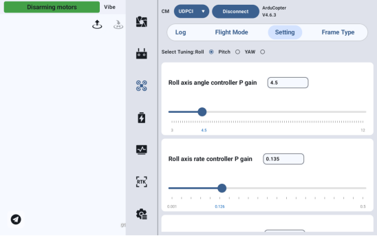
UniGCS v3.0 eliminates the need for external tuning software. The integrated suite covers every critical aspect of flight controller configuration—from PID response curves to ESC signal calibration.
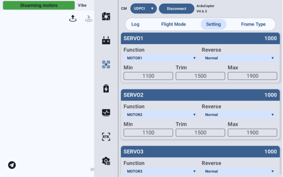
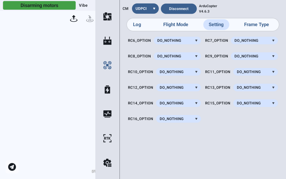
Adjust roll, pitch, and yaw control response with radio-button axis selection and real-time slider feedback. Configure SERVO1 through SERVO16 channel mappings, set PWM min/trim/max values, and reverse servo movement directly. Bind auxiliary channels (RC6–RC16) to functions like flight mode switching, payload dropping, and arming/disarming.
- PID tuning with slider and direct input for roll, pitch, yaw
- Servo configuration: normal/reverse, min/trim/max PWM
- RC IN settings for auxiliary channel function binding
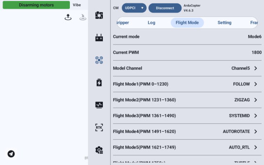
- Flight mode setup with 6 preset PWM levels (AUTO, RTL, etc.)
- Frame type selection with power layout auto-loading
- Battery module calibration and low-voltage failsafe
- Motor testing (individual/batch) with custom throttle %
- ESC calibration with PWM/RPM range configuration
- Airspeed sensor calibration with pitot tube procedure
- Parameter table edit password protection
Personalized OSD & Voice Alerts
Every pilot has unique preferences. UniGCS v3.0 empowers users to customize their entire operational interface without touching a single line of code.
Long-press any telemetry data around the attitude indicator to configure font size, color, and display position. The new voice broadcast system supports custom alert intervals, individual alert enable/disable toggles, and fully user-defined announcement content. Critical safety checks like one-click arming/disarming—with force-arm override for failed checks—are now accessible from the main interface.
- Customizable OSD: font size, color, position around attitude ball
- Voice alerts: enable/disable, custom intervals, user-defined content
- One-click arming/disarming with force-override capability
- Three/six flight mode quick-switching on single channel
- Gimbal scan connection for automatic camera detection
Intelligent Route Planning Evolved
Building on the v2.0 foundation, UniGCS v3.0 introduces three route shape options and advanced mission visualization tools that transform pre-flight planning from chore to precision.
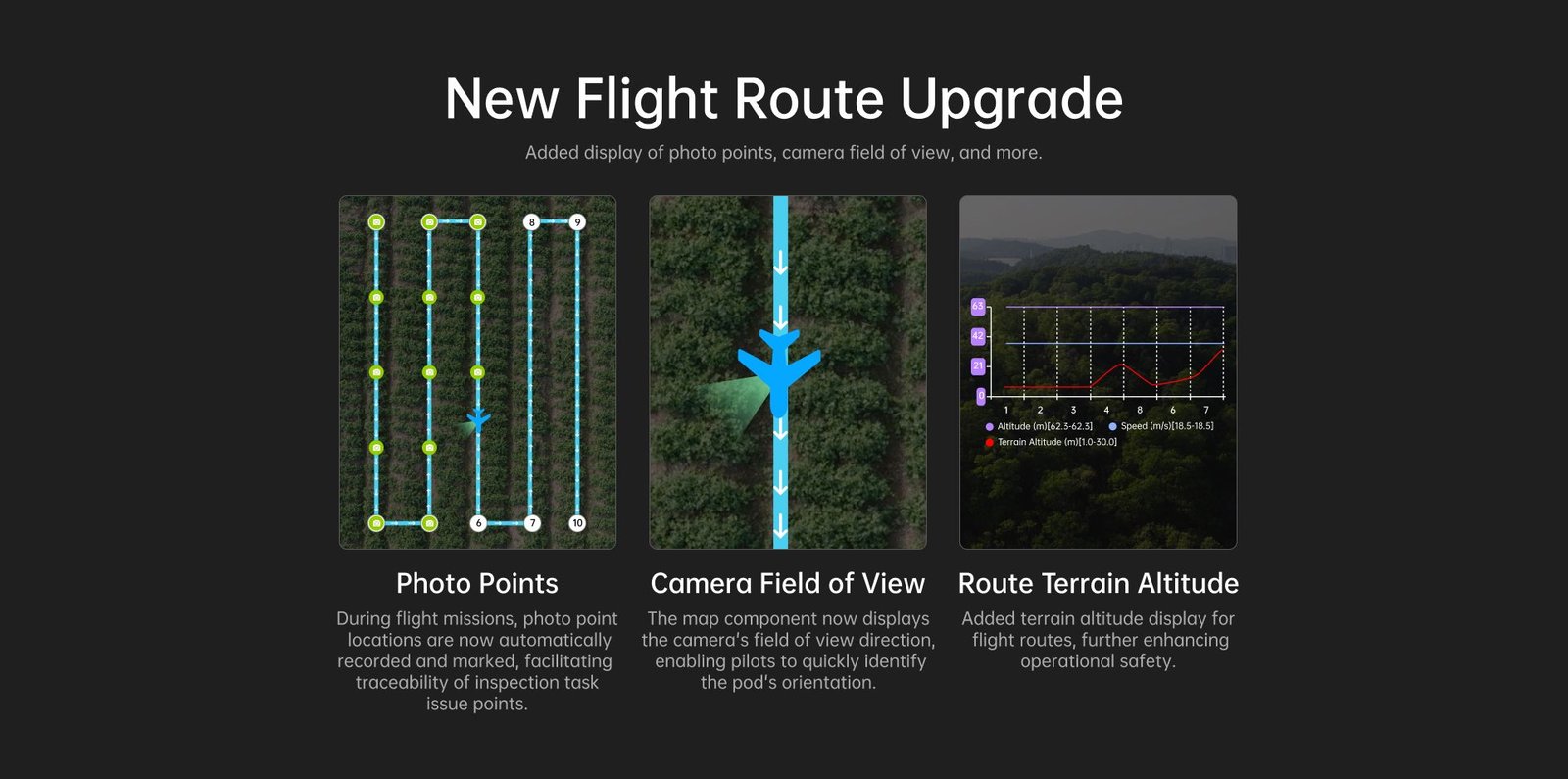
Generate rectangular routes with 4 draggable waypoints or circular routes with up to 300 points—radius and center defined by map interaction. Waypoint photo points display shutter trigger positions along the route for inspection traceability. Camera FOV angle visualization shows the camera’s field of view relative to the drone, enabling rapid gimbal angle adjustments mid-flight. The updated pre-flight check now includes route terrain elevation display, with optional local .TIF terrain-following files when network data is unavailable.
- Custom, rectangular, and circular route shapes
- Waypoint photo points with shutter trigger display
- Camera FOV angle visualization during route flight
- Loiter point radius configuration
- Flight trajectory length configuration
- Route terrain elevation display in pre-flight check
- Local .TIF terrain-following file support
Security Log & Playback
Flight safety demands accountability. UniGCS v3.0 introduces comprehensive telemetry log playback and flight controller log management—turning every mission into a data-rich learning opportunity.
Telemetry data is automatically recorded locally on the ground control station. Post-flight, replay the entire mission with dynamic trajectory display on the map, synchronized altitude and speed telemetry, and aircraft status tracking at any timestamp. Flight controller logs can be managed, viewed, downloaded, and maintained directly within the software—streamlining incident analysis and performance optimization.
- Automatic local telemetry recording during flight
- Dynamic flight trajectory replay on map
- Real-time altitude/speed sync during playback
- Aircraft status and landing point tracking
- Flight controller log management (view/download/maintain)
Open Ecosystem Compatibility
UniGCS v3.0 is built on ArduPilot and PX4 open-source protocols, delivering full MAVLink compatibility for seamless integration with your existing unmanned infrastructure.
MAVLink Native, Open-Source Ready
Developed on ArduPilot and PX4 protocols, UniGCS v3.0 is compatible with all MAVLink ecosystem products. Whether you’re flying a multi-rotor UAV for aerial surveying or a VTOL platform for long-range patrol, the software adapts to your hardware—not the other way around.
When paired with SIYI handheld ground stations and integrated data link systems, UniGCS v3.0 forms a complete command chain from base station to airborne platform. For extended BVLOS operations, antenna tracking systems and portable power stations integrate seamlessly into the workflow.
- Full ArduPilot / PX4 firmware compatibility
- MAVLink protocol native support
- SIYI gimbal and data link integration
- Third-party camera and payload support
- Parameter import/export across devices
Get UniGCS v3.0.1 Today
Available for standard Android ground stations and MK15/MK32 dedicated versions. Auto-update enabled for existing installations.
Related SoarApex Systems
Complete your ground control ecosystem with our integrated unmanned solutions.
External Resources
Official documentation, protocol references, and industry standards for ground control station software.
Official UniGCS v3.0 product announcement and technical specifications from SIYI TECHNOLOGY.
Open-source micro air vehicle communication protocol powering UniGCS and the broader drone ecosystem.
Trusted open-source autopilot platform fully compatible with UniGCS v3.0 flight controller tuning suite.
Professional-grade open-source flight control stack supported by UniGCS v3.0 ground station software.
Comprehensive overview of ground control station technology, applications, and industry standards.
Upgrade to UniGCS v3.0 Today
Experience one-stop flight controller tuning, intelligent route planning, and professional telemetry management. Contact SoarApex for integration support, compatibility verification, and ecosystem quotes.
Request a Quote