
Forests shelter 80% of Earth’s terrestrial species. Forestry departments now deploy multi-rotor UAV drones to monitor wildlife distributions, population dynamics, and habitat changes with minimal disturbance—slashing field risks while boosting patrol efficiency.
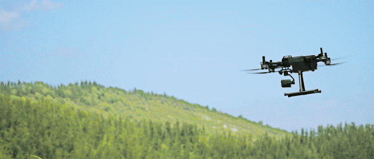
Forest Patrol Operational Challenges
Wildlife protection in dense forest environments presents unique technical hurdles that demand purpose-built unmanned systems.
Canopy Interference
Dense foliage blocks visible-light observation. Extensive tree canopies restrict the capabilities of standard EO cameras, making ground-level wildlife and poacher detection nearly impossible from altitude.
Signal Degradation
Trees strongly absorb radio waves, causing data link transmission failures. Control signals and video feeds are prone to interruption in heavily wooded terrain, breaking the operator’s situational awareness.
Turbulent Terrain
Mountain winds and turbulent airflows in forested valleys severely test flight stability. Magnetic interference from mineral deposits further complicates navigation, risking platform loss in remote areas.
Professional Operation Threshold
Open-source systems overwhelm frontline rangers. Complex configuration, calibration, and mission planning workflows create steep learning curves that delay deployment and reduce operational readiness.
Integrated Ecosystem Architecture
SIYI delivers a unified wildlife drone patrol solution combining the ZT30 multi-sensor payload, UniRC 7Pro ground control station, N7 autopilot, and UniGCS software.
ZT30 Optical Pod
4K EO + 640×512 IR + LRF
30x optical / 180x hybrid zoom
AI fire detection & tracking
UniRC 7Pro GCS
40km dual-frequency transmission
2.4G/5G auto-hopping
Dual-operator mode
N7 Autopilot
Dual IMU redundancy
Dual magnetometers
Heated IMU for -20°C
UniRC 7Pro: 40km Dual-Frequency Command Center
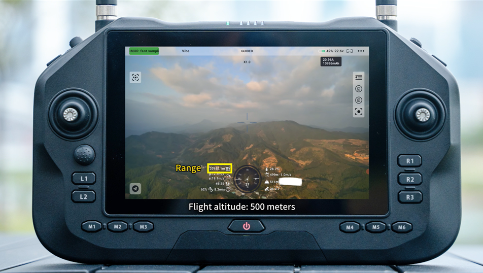
Launched in October 2024, the UniRC 7 series has proven exceptional in forest patrol scenarios. Its stable long-distance image transmission and 2.4G & 5G automatic frequency hopping overcome the signal absorption challenges posed by dense woodland.
Validation tests confirm 12.5km range at 200m altitude and 20km at 500m—maintaining clear feeds despite heavy signal attenuation. The dedicated gimbal joystick enables target locking mid-flight, while dual-operator mode allows pilot and payload specialist collaboration, reducing individual skill thresholds.
- 40km stable transmission with dual-band auto-switching
- 2.4GHz/5GHz seamless frequency hopping
- Dedicated gimbal joystick for real-time target tracking
- Dual-operator mode for pilot + payload specialist
ZT30: Seeing Through the Canopy
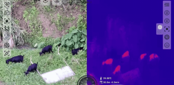
Even when rapid Wildlife Drone Patrol flights operate above the tree canopy, dense vegetation limits visible-light observation. The ZT30 four-sensor optical pod integrates 4K ultra-wide camera, 30x optical zoom, 640×512 infrared camera, and laser rangefinder—providing multi-spectral vision for forest patrol drones.
Dual-screen IR/visible light imaging detects hidden animals and poachers in all conditions. The laser rangefinder pinpoints GPS coordinates of wildlife sightings, while integrated AI fire detection adds smoke recognition for comprehensive forest protection.
- 4K ultra-wide EO + 640×512 IR thermal sensor
- 30x optical / 180x hybrid zoom through canopy
- Dual-screen EO/IR with linked zoom
- Laser rangefinder for precise GPS coordinates
- AI fire detection and smoke recognition
N7 Autopilot: Stability Redefined for Harsh Environments
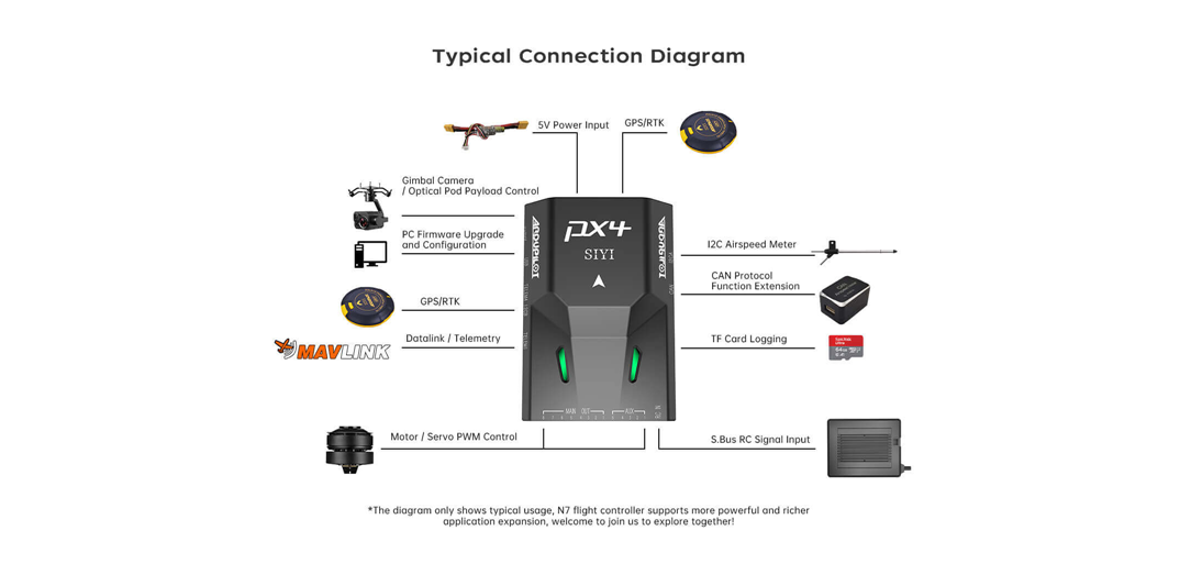
Wildlife habitats deep in mountainous forests subject UAV platforms to turbulent airflows and magnetic interference from mineral deposits. The N7 industrial-grade autopilot, built on open-source ArduPilot and PX4 ecosystems, delivers battle-tested reliability with enhanced redundancy.
Dual IMU redundancy prevents crash scenarios from single-sensor failure. Dual magnetometers counter magnetic interference, while the heated IMU ensures operation down to -20°C. Paired with cm-accuracy RTK, the N7 maintains precise position hold even in turbulent valleys—critical for multi-rotor UAV patrols over uneven terrain.
- Dual IMU redundancy with internal shock absorption
- Dual magnetometers for magnetic interference resilience
- Heated IMU enabling -20°C cold-weather operations
- cm-accuracy RTK positioning in turbulent valleys
- ArduPilot / PX4 firmware compatibility
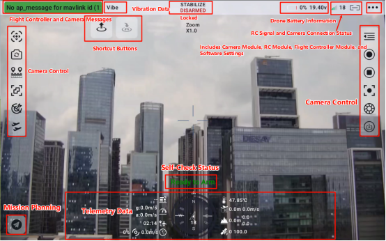
UniGCS: Simpler, More Compatible Drone Control
SIYI’s UniGCS ground station software bridges open-source and closed-source advantages. Developed on ArduPilot and PX4 protocols, it is compatible with all MAVLink ecosystem products—while presenting a control interface as intuitive as an iPad.
Auto-patrol routes enable one-touch takeoff and landing, freeing rangers to focus on observation rather than piloting. Smart fail-safes trigger automatic return-home on critical alerts. The centralized dashboard displays airspeed, altitude, and wind data at a glance—transforming complex open-source operations into smartphone-simple workflows.
- Smartphone-simple interface with integrated functions
- Auto-patrol route planning with one-touch execution
- Smart fail-safes: automatic return-home on alerts
- Centralized telemetry dashboard for airspeed, altitude, wind
- Full MAVLink / ArduPilot / PX4 compatibility
Real-World Operational Impact
This integrated wildlife drone patrol solution already empowers dozens of conservation projects across China’s Qinling Mountains, Greater Khingan Range, and Xishuangbanna rainforests.

Replacing High-Risk Manual Patrols
Rangers now conduct surveys from station bases, slashing exposure to hazardous terrain while accelerating response times. Thermal-equipped multi-rotor UAVs have become critical anti-poaching tools, enabling teams to detect hidden threats through infrared vision that penetrates dense canopy cover.
When paired with portable power stations for extended field operations and antenna tracking systems for beyond-visual-line-of-sight missions, the ecosystem delivers complete patrol coverage from deployment to reporting.
- Remote-controlled precision replaces foot patrols in dangerous terrain
- Infrared detection of poachers and wildlife through canopy cover
- Accelerated response times from centralized command stations
- Scalable deployment across diverse forest ecosystems
Related SoarApex Systems
Complete your wildlife patrol ecosystem with our integrated unmanned solutions.
External Resources
Authoritative references for wildlife conservation technology, UAV regulations, and anti-poaching best practices.
Official SIYI TECHNOLOGY product announcement for the wildlife drone patrol ecosystem solution.
International Union for Conservation of Nature — global authority on species status and habitat protection, like wildlife drone patrol.
Open-source micro air vehicle communication protocol powering the UniGCS ground station and N7 autopilot.
Trusted open-source autopilot platform fully compatible with the N7 flight controller ecosystem.
Convention on International Trade in Endangered Species — regulatory framework for wildlife protection enforcement through wildlife drone patrol .
Deploy Wildlife Drone Patrol Today
The SIYI wildlife drone patrol ecosystem is available now through SoarApex. Contact us for ecosystem integration support, platform compatibility verification, and complete conservation system quotes for wildlife drone patrol solutions and more.
Request a Quote